Skip to content
Road · Gravel · MTB · United States

The first AI agent for your next ride.

Say one sentence — Rieda knows the surface and builds your ride.

Start free. Sign up with email or Google.

For road, gravel and MTB

Ride exactly what you pictured.

Road

Verified tarmac. Unknown surface counts as risk, and big roads never make the loop.

99.9% tarmac0.1% untagged & other
Distance
40.7 mi
Climbing
1,877 ft
Tarmac
99.9%

All three loops are real output from the US graph — numbers exactly as the router returned them.
The difference

Millions of roads never say what they are made of.

Most planners assume tarmac. We plan with the truth — the road bike goes around, the gravel bike goes through.

52 %
surface known

48 % no surface tag — counted as risk

Surface-tag coverage of German roads in OpenStreetMap — StreetSurfaceVis, 2024.

How it comes out

One sentence in. One rideable loop out.

40.7 mi
Distance
1,877 ft
Climbing
100 %
Tarmac

37 miles from Boulder, a bit rolling

The AI reads your sentence. A routing graph picks the roads.

See it

The app, with a real loop.

Rieda
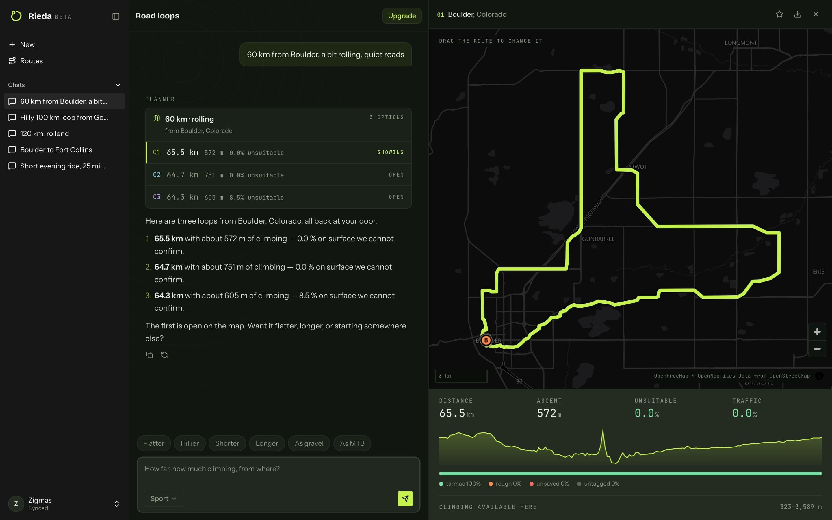
The full Rieda app: sidebar, chat with three scored loops, and the map drawing the open 40.7-mile route.
Sidebar · chat · live map — a real 40.7-mile loop with 1,877 ft of climbing, exactly as the router returned it

One sentence, three checked loops

You do not get a route. You get the best three of 20, ranked by what matters.

01 · Ask
37 miles from Boulder, a bit rolling
37 mi · rolling
from Boulder, Colorado
3 options

See what you are riding on

Tap any point: surface, way type, gradient. This one is grass — and you know before you are standing on it.

02 · Check the roads
Waypoint 1
40.040017, -105.269900
After
2.2 mi
Elevation
5,394 ft
Incline
-2.3 %
Surface
Concrete
Way type
Cycleway

Surface wrong here?

Everything at a glance

Elevation profile, surface split, and the numbers you actually decide on.

03 · Read the profile
Distance
40.7mi
Ascent
1,877ft
Unsuitable
0.0%
Traffic
0.0%
tarmac 100%rough 0%unpaved 0%untagged 0%
Climbing available here3233,589 m

Road.Gravel. MTB.Nothing else.

What you get

Pick your sport. Not “a bicycle”.

SURFACE

No surprise gravel

When in doubt, the road ride goes around — untagged ways included. Gravel and MTB flip that on purpose.

99.9% tarmac0.1% untagged0% unpaved
TRAFFIC

Quiet roads

Big roads never make it into the loop.

Big roads0.0 %
0share of the loop
CLIMBING

Flat or hilly

Your target profile, checked honestly against the terrain.

Elevation572 m · 65.5 km
SHAPE

A loop — or A to B

Start and finish at your door, no road twice. Or straight across: “Denver to Boulder”.

LOOP
A TO B
EDIT

Change it your way

Drag the line — or just say it.

“37 miles from Boulder, past a coffee stop”
EXPORT

Straight to your device

One click, one GPX — ready for the head unit.

66-km-rolling-from-boulder.gpx
Garmin · Wahoo · Karoo
Example rides

Real output, not mockups.

Boulder foothills loop

40.7 mi1,877 ft

The classic Front Range spin — 99.9 % tarmac, no traffic to speak of.

99.9 % tarmacQuiet roadsFront Range

Golden hill loop

40.4 mi2,717 ft

Climbing straight out of town: 2,717 ft up, still 89 % tarmac.

2,717 ft climbing89 % tarmacHilly

Fort Collins flat loop

27.1 mi702 ft

Pancake flat through farmland — the loop for interval days.

95 % tarmacFlatIntervals
A→B

Denver to Boulder

34.4 mi2,106 ft

Straight across instead of round in a circle — ride out, train back.

A to B86 % tarmacOne-way

Steamboat Springs gravel

33.2 mi3,822 ft

Ranch roads and forest tracks: 57 % unpaved with 3,822 ft of climbing.

57 % unpaved3,822 ft climbingGravel

Salida gravel loop

27.7 mi3,829 ft

Nearly four fifths off the tarmac, high in the Arkansas valley.

79 % unpaved3,829 ft climbingGravel

Fruita desert gravel

26.7 mi1,414 ft

Desert two-track under the Book Cliffs — 39 % unpaved, dry all year.

39 % unpavedDesertGravel

Durango forest tour

27.2 mi3,701 ft

73 % unpaved with 3,701 ft of climbing — forest roads up, real descents down.

73 % unpaved3,701 ft climbingMTB

Crested Butte high country

22.7 mi4,291 ft

Almost no tarmac at all: 99.6 % unpaved, 4,291 ft up.

99.6 % unpaved4,291 ft climbingMTB

Grand Junction rim tour

26.3 mi1,398 ft

Slickrock country — 48 % unpaved with the desert to yourself.

48 % unpavedDesertMTB

One sentence. And you have a loop.

One sentence is enough. Sign up with email or Google.

Plan your first loop
The difference

Where other planners stop.

Typical route plannersRieda
Planningforms, sliders, clicksone sentence in chat
Unknown surfaceassumed rideablecounted as risk
Circuitsoften there-and-backa genuine loop, scored
Climb targeta fixed number, wherever you livewhat is achievable from your door
Choiceone route20 scored, best three shown
Changesdrag waypointsdrag — or just say it
Pricing

Start free. Pay when it earns it.

Ten loops a month are free. You pay for volume — and for having your loops on every device.

Free
Best for: trying it out
$0forever
  • 10 loops planned or adjusted per month
  • Full route editing
  • GPX export for Garmin & Wahoo
  • Save your loops
Get started
Popular
Pro
Best for: training every week
$45per year
  • No monthly limit on planning or adjusting
  • Synced across your devices
  • Unlimited library
  • New features first
Go Pro

Prices in US dollars. Any sales tax is shown at checkout. Cancel any time. Fair use: 150 planned or adjusted loops a month. Need more? Talk to us and we will sort it out.

Questions

Answered briefly.

The five that actually decide it. The rest are one page away.

See all questions
Why not just use Komoot?

Komoot does almost everything — and it is built for every kind of bike. That is exactly why a way with no surface tag counts as rideable there. Here the sport decides: the road loop goes around it, and the gravel loop has its own model that hunts the tracks instead of avoiding them.

How do I know a loop is any good?

You do not have to take our word for it — you can see it. Every loop states how much is tarmac, how much is gravel and how much is untagged, before you ride. Tap any point on the line and it tells you the surface right there.

Which region is covered?

The United States. Colorado is where it is developed and tested first — every example ride on this page is real output from that data. Other countries have a waiting list.

Does it work with my Garmin?

Yes. Export is a GPX file with real elevation — Garmin, Wahoo, Karoo and anything else that imports courses.

Can I cancel any time?

Yes, monthly, one click in your account — access runs to the end of the paid period. And you keep the ten free loops a month afterwards anyway.
Other countries

Not your country yet?

Rieda currently plans in the United States only. Tell us where you ride — the list decides which country comes next.

Your next loop is one sentence away.

Describe it, look it over, put it on the head unit.

Plan your first loop
Free to start · no tracking · delete any time